![](/images/other/stat-length.png)
![Tocht Stappen Les Angles - Randonnée hivernale Angles - Yglesiette (reste village médiéval) - Photo](https://media.geolcdn.com/t/1900/400/10738cad-fca0-4242-8705-840dc6589786.jpg&format=pjpeg&maxdim=2)
Randonnée hivernale Angles - Yglesiette (reste village médiéval)
prous31
Gebruiker
![Lengte](/images/other/stat-length.png)
Lengte
7,4 km
![Max. hoogte](https://static1.geolcdn.com/siteimages/upload/files/1508320355ic_sort_altitude_max_24dp.png)
Max. hoogte
1796 m
![Positief hoogteverschil](https://static1.geolcdn.com/siteimages/upload/files/1508320355ic_sort_den_pos_24dp.png)
Positief hoogteverschil
168 m
![Km-Effort](/images/other/stat-length.png)
Km-Effort
9,6 km
![Min. hoogte](https://static1.geolcdn.com/siteimages/upload/files/1508320355ic_sort_altitude_min_24dp.png)
Min. hoogte
1663 m
![Negatief hoogteverschil](https://static1.geolcdn.com/siteimages/upload/files/1508320355ic_sort_den_neg_24dp.png)
Negatief hoogteverschil
170 m
![Boucle](https://static1.geolcdn.com/siteimages/upload/files/16400158638029165_repeat_loop_refresh_sync_direction_icon.png)
Boucle
Ja
Datum van aanmaak :
2020-02-11 09:08:36.602
Laatste wijziging :
2020-10-25 16:01:42.615
![Stappen](https://static1.geolcdn.com/sitytour/trail-icons/101.png)
2h49
Moeilijkheid : Heel gemakkelijk
![Scan deze QR-code om de tocht te openen in de SityTrail-applicatie](https://capi.geolives.com/qq0zvz2zws4bq2lad0pu/sitytour/trails/2331240/qr.png?size=200)
Gratisgps-wandelapplicatie
Over ons
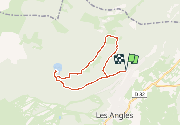
Tocht Stappen van 7,4 km beschikbaar op Occitanië, Pyrénées-Orientales, Les Angles. Deze tocht wordt voorgesteld door prous31.
Beschrijving
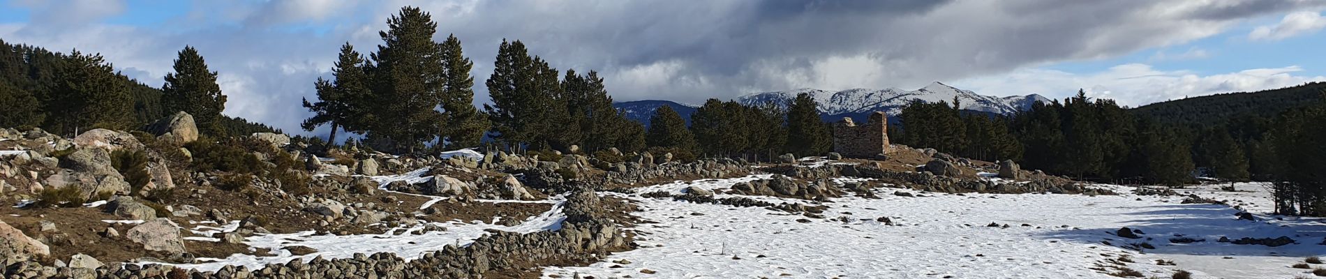
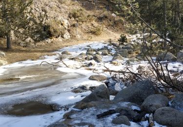
Randonnée facile au depart des Angles vers Yglésiette puis lac de Balcére.
Peut se faire aussi bien en hiver (en apres ski ou raquette si vraiment beaucoup de neige) qu'en été
Plaatsbepaling
Land:
France
Regio :
Occitanië
Departement/Provincie :
Pyrénées-Orientales
Gemeente :
Les Angles
Locatie:
Unknown
Vertrek:(Dec)
Vertrek:(UTM)
424249 ; 4715592 (31T) N.
Opmerkingen
Wandeltochten in de omgeving
![Tocht Sneeuwschoenen Les Angles - Lac d Aude -Refuge Bernardi les Angles - Photo](https://media.geolcdn.com/t/375/260/ext.jpg?maxdim=2&url=https%3A%2F%2Fservices.sitytrail.com%2FGeolivesWS%2FDownloadMedia.ashx%3FTrailID%3D400729%26Media%3Dfix__20150327134406.jpg)
![Sneeuwschoenen Sneeuwschoenen](https://static1.geolcdn.com/sitytour/trail-icons/504.png)
Lac d Aude -Refuge Bernardi les Angles
Sneeuwschoenen
Medium
(1)
Les Angles,
Occitanië,
Pyrénées-Orientales,
France
![](/images/other/stat-length.png)
13,9 km | 19,1 km-effort
5h 44min
![](https://static1.geolcdn.com/siteimages/upload/files/16400158638029165_repeat_loop_refresh_sync_direction_icon.png)
Ja
![Tocht Stappen Les Angles - lac d'Aude - Photo](https://media.geolcdn.com/t/375/260/dc6c3cf8-db43-4620-818b-ca96b3366767.jpg&format=jpg&maxdim=2)
![Stappen Stappen](https://static1.geolcdn.com/sitytour/trail-icons/101.png)
lac d'Aude
Stappen
Medium
Les Angles,
Occitanië,
Pyrénées-Orientales,
France
![](/images/other/stat-length.png)
13,8 km | 0 m-effort
5h 57min
![](https://static1.geolcdn.com/siteimages/upload/files/16400158638029165_repeat_loop_refresh_sync_direction_icon.png)
Ja
![Tocht Stappen Les Angles - Lac d'Aude en boucle - Photo](https://media.geolcdn.com/t/375/260/bb545742-b218-4a2b-8572-21d45496180e.jpg&format=jpg&maxdim=2)
![Stappen Stappen](https://static1.geolcdn.com/sitytour/trail-icons/101.png)
Lac d'Aude en boucle
Stappen
Medium
Les Angles,
Occitanië,
Pyrénées-Orientales,
France
![](/images/other/stat-length.png)
13,8 km | 19,9 km-effort
6h 8min
![](https://static1.geolcdn.com/siteimages/upload/files/16400158638029165_repeat_loop_refresh_sync_direction_icon.png)
Ja
![Tocht Stappen Les Angles - les Angles - Photo](https://media.geolcdn.com/t/375/260/a1624f8b-9696-405f-8c28-1fd4c2634375.jpg&format=jpg&maxdim=2)
![Stappen Stappen](https://static1.geolcdn.com/sitytour/trail-icons/101.png)
les Angles
Stappen
Moeilijk
Les Angles,
Occitanië,
Pyrénées-Orientales,
France
![](/images/other/stat-length.png)
14,5 km | 20 km-effort
4h 58min
![](https://static1.geolcdn.com/siteimages/upload/files/16400158638029165_repeat_loop_refresh_sync_direction_icon.png)
Neen
![Tocht Stappen Formiguères - Les Camporells par la Lladure - Photo](https://media.geolcdn.com/t/375/260/ext.jpg?maxdim=2&url=https%3A%2F%2Fstatic1.geolcdn.com%2Fsiteimages%2Fupload%2Ffiles%2F1553511878bg_sport_marche.png)
![Stappen Stappen](https://static1.geolcdn.com/sitytour/trail-icons/101.png)
Les Camporells par la Lladure
Stappen
Medium
(1)
Formiguères,
Occitanië,
Pyrénées-Orientales,
France
![](/images/other/stat-length.png)
15,1 km | 24 km-effort
5h 7min
![](https://static1.geolcdn.com/siteimages/upload/files/16400158638029165_repeat_loop_refresh_sync_direction_icon.png)
Ja
![Tocht Sneeuwschoenen Les Angles - lac d aude - Photo](https://media.geolcdn.com/t/375/260/ext.jpg?maxdim=2&url=https%3A%2F%2Fstatic1.geolcdn.com%2Fsiteimages%2Fupload%2Ffiles%2F1524743153raquette.jpg)
![Sneeuwschoenen Sneeuwschoenen](https://static1.geolcdn.com/sitytour/trail-icons/504.png)
lac d aude
Sneeuwschoenen
Heel gemakkelijk
(2)
Les Angles,
Occitanië,
Pyrénées-Orientales,
France
![](/images/other/stat-length.png)
14,5 km | 20 km-effort
Onbekend
![](https://static1.geolcdn.com/siteimages/upload/files/16400158638029165_repeat_loop_refresh_sync_direction_icon.png)
Ja
![Tocht Stappen Les Angles - boucle de la Balmette par le mont Llaret et le roc d'aude - Photo](https://media.geolcdn.com/t/375/260/ext.jpg?maxdim=2&url=https%3A%2F%2Fstatic1.geolcdn.com%2Fsiteimages%2Fupload%2Ffiles%2F1553511878bg_sport_marche.png)
![Stappen Stappen](https://static1.geolcdn.com/sitytour/trail-icons/101.png)
boucle de la Balmette par le mont Llaret et le roc d'aude
Stappen
Medium
(2)
Les Angles,
Occitanië,
Pyrénées-Orientales,
France
![](/images/other/stat-length.png)
17,2 km | 28 km-effort
Onbekend
![](https://static1.geolcdn.com/siteimages/upload/files/16400158638029165_repeat_loop_refresh_sync_direction_icon.png)
Ja
![Tocht sport Formiguères - 20240728 Station Formiguères - Camporeils - Photo](https://media.geolcdn.com/t/375/260/f876415d-ce02-429d-b141-5520f07207a5.jpg&format=jpg&maxdim=2)
20240728 Station Formiguères - Camporeils
sport
Heel gemakkelijk
Formiguères,
Occitanië,
Pyrénées-Orientales,
France
![](/images/other/stat-length.png)
16 km | 27 km-effort
Onbekend
![](https://static1.geolcdn.com/siteimages/upload/files/16400158638029165_repeat_loop_refresh_sync_direction_icon.png)
Ja
![Tocht Stappen La Llagonne - 2024-01-22 Les bouillouses - Photo](https://media.geolcdn.com/t/375/260/00fa4e59-6f74-4341-a071-bd92950f8772.jpg&format=jpg&maxdim=2)
![Stappen Stappen](https://static1.geolcdn.com/sitytour/trail-icons/101.png)
2024-01-22 Les bouillouses
Stappen
Moeilijk
La Llagonne,
Occitanië,
Pyrénées-Orientales,
France
![](/images/other/stat-length.png)
10,3 km | 15 km-effort
3h 25min
![](https://static1.geolcdn.com/siteimages/upload/files/16400158638029165_repeat_loop_refresh_sync_direction_icon.png)
Ja